Colorado Springs sits on a complex geologic interface where the Great Plains meet the Rocky Mountain foothills, creating a profile dominated by the expansive Pierre Shale, interbedded sandstone, and loose colluvial fans from the Rampart Range. This means any excavation deeper than 10 feet here encounters materials with wildly different swell potential, groundwater seepage paths, and stand-up time. We apply continuous geotechnical excavation monitoring to track lateral deformation, pore pressure shifts, and settlement in real-time, protecting adjacent structures along corridors like Nevada Avenue or the Old North End. Our field team uses automated total stations and multiplexed inclinometers, directly referencing site-specific parameters from the triaxial testing program that defines the strength envelope of the local bedrock. Without this monitoring loop, the variable saturation of the Dawson Arkose can turn a routine utility cut into a costly slope failure within hours.
In Colorado Springs, the difference between a controlled dig and a costly repair is often a matter of millimeters—caught early by properly scaled monitoring.
Technical details of the service in Colorado Springs
Risks and considerations in Colorado Springs
One thing we see repeatedly in Colorado Springs is the delayed reaction of the Pierre Shale to unloading. You can finish an excavation in dry conditions, and three days later, moisture migration from a broken irrigation line two lots over triggers a progressive sloughing that the initial inspection missed. The biggest financial exposure isn't the excavation collapse—it's the adjacent property damage. A settling sidewalk on a 1920s Craftsman home in the Old North End can generate a claim that dwarfs the original monitoring budget. We mitigate this by establishing pre-construction condition surveys with crack gauges on all structures within the zone of influence, defined here as 1.5 times the excavation depth. The data feeds directly into a threshold action plan: amber alerts at 50% of design movement, red at 80%. This isn't just instrumentation—it's a defensible risk management protocol that holds up when the bentonite seams in the shale decide to hydrate.
Our services
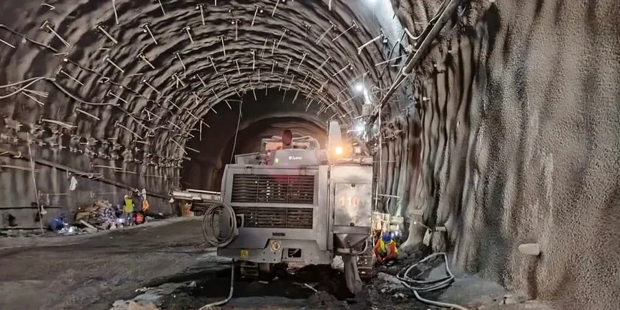
Our monitoring programs in Colorado Springs are built around two core service lines that integrate directly with the general contractor's schedule and the geotechnical baseline report. We don't just hand you data—we provide interpretation tied to the specific failure modes of the local formations.
Deep Excavation Instrumentation Package
Designed for cuts exceeding 20 feet or shoring-supported excavations. Includes automated total station arrays with prism targets on soldier piles, in-place inclinometers behind the shoring, and multi-point borehole extensometers to track settlement at depth. Data streams to a cloud dashboard with user-defined trigger levels per the project's IBC 3304 compliance plan. This package is typical for mid-rise foundation digs in downtown Colorado Springs.
Adjacent Structure Protection Monitoring
Focused on the zone of influence around shallow utility trenches and basement excavations in historic districts. Deployments include high-resolution crack gauges on brittle finishes, precise leveling surveys on structural columns, and wireless tiltmeters on retaining walls. We establish the baseline during the pre-construction survey and run continuous comparisons, delivering weekly summary reports with movement vector plots that demonstrate compliance to the building official.
Frequently asked questions
How often does the monitoring system send alerts during an excavation in Colorado Springs?
Our systems are configured to push alerts immediately when a threshold is breached. During active excavation, we typically set amber alerts at 50% of the allowable movement and red alerts at 80%. The data sampling rate is adjustable: we can take readings every 15 minutes during critical shoring removal or every hour during stable holding periods. All alerts are sent via SMS and email to the project superintendent and the geotechnical engineer of record, with a follow-up phone call for any red-level trigger.
What is the typical cost range for geotechnical excavation monitoring on a commercial project in Colorado Springs?
How do you handle the freeze-thaw cycle effects on monitoring data here?
At 6,035 feet elevation, Colorado Springs sees significant diurnal temperature swings that can create false movement signals in shallow instruments. We compensate by installing inclinometer casing with deep anchors socketed into bedrock, bypassing the active frost zone. For surface settlement points, we use thermally stable invar rods and apply temperature corrections to all electronic displacement sensors. Our baseline surveys are always conducted at a consistent time of day to minimize thermal expansion noise in the optical survey data.
What happens if the monitoring data shows movement exceeding the design limit?
The moment a red threshold is reached, our protocol triggers an immediate work stoppage in the affected zone and a visual inspection by our field engineer. We verify the reading with a secondary manual measurement—typically a digital inclinometer probe run or an independent total station check shot—to rule out sensor drift. If the movement is confirmed, we issue an incident report within two hours outlining the magnitude, vector direction, and probable mechanism, allowing the design team to implement contingency measures like additional bracing or revised sequencing.